
Critical Habitat for Endangered Species in Washington
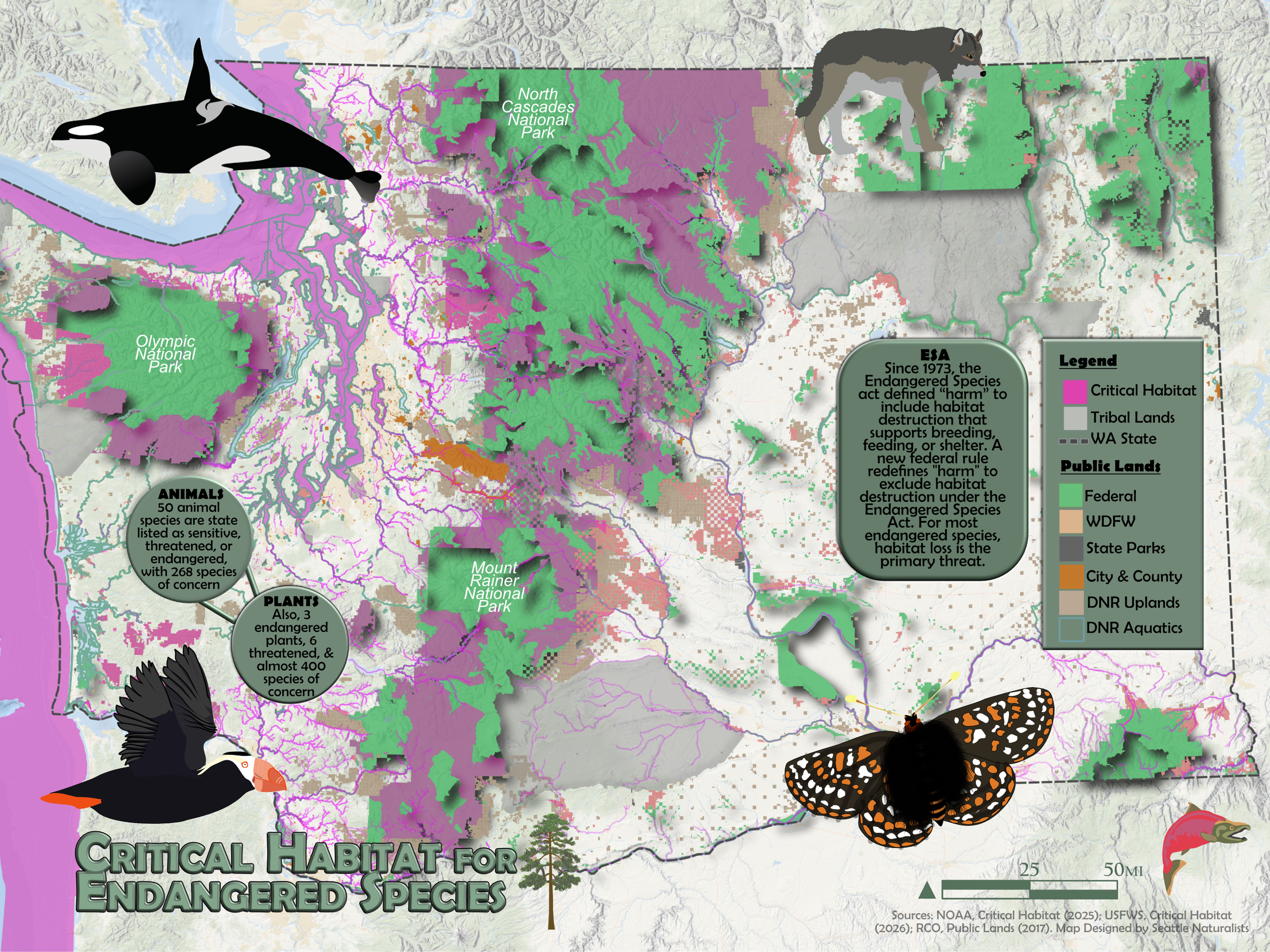
Critical Habitat for Endangered Species in Washington State:
With the new federal definition change of habitat, I wanted to create a map that shows just how much federal land (the green areas) is in Washington. Turns out, it’s about 20% or ~12 million acres. I also wanted to see how much of that federal land, and waters, are designated as critical habitat (the pink areas). As you can see, it’s quite significant.
Habitat loss remains the leading driver of extinction. Many of these landscapes remain connected through forests, wildlife area, parks, and tribal lands, creating wildlife corridors that support migration, breeding, and long-term resilience.
In the state, there are ~50 animal species state listed as sensitive, threatened, or endangered, with 268 additional animal species of concern. Also on the docket are 3 endangered plants, 6 threatened, and nearly 400 plant species of concern.
Since 1973, the Endangered Species Act has recognized that destroying habitat can “harm” endangered species because they depend on these places for breeding, feeding, shelter, and recovery. The new federal rule removes habitat destruction from that definition of “harm” despite habitat loss being the primary threat facing most endangered species.
Featured on map:
Tufted puffin:
State Status | Endangered
Federal ESA Status | None
Killer whale:
State Status | Endangered
Federal ESA Status | Multiple
Whulge (Taylor’s) checkerspot
State Status | Endangered
Federal ESA Status | Multiple
Gray wolf
State Status | Endangered
Federal ESA Status | Multiple
To learn more about all the threatned and endangered species in Washington, view the Washington Department of Fish & Wildlife’s website: https://wdfw.wa.gov/species-habitats/at-risk/listed
Sources:
Washington Department of Fish and Wildlife. (n.d.). Threatened and endangered species. Retrieved July 28, 2026, from https://wdfw.wa.gov/species-habitats/at-risk/listed
National Oceanic and Atmospheric Administration Fisheries. (2026, February 3). National ESA critical habitat mapper. NOAA Fisheries. https://www.fisheries.noaa.gov/resource/map/national-esa-critical-habitat-mapper
U.S. Fish and Wildlife Service. (n.d.). US Fish and Wildlife Service open data. Retrieved July 28, 2026, from https://gis-fws.opendata.arcgis.com/
U.S. Fish and Wildlife Service. (n.d.). ECOSphere: USFWS threatened & endangered species active critical habitat report. Environmental Conservation Online System. Retrieved July 28, 2026, from https://ecos.fws.gov/ecp/report/table/critical-habitat.html
Washington State Recreation and Conservation Office. (n.d.). ArcGIS. Retrieved July 28, 2026, from https://wa-rco.maps.arcgis.com/apps/dashboards/2f8aa05d2a074cc0b4e18cb0b88006ab
Washington State Department of Ecology. (n.d.). Tribal lands. Washington State Geospatial Open Data Portal. Retrieved July 28, 2026, from https://geo.wa.gov/datasets/waecy::tribal-lands/explore
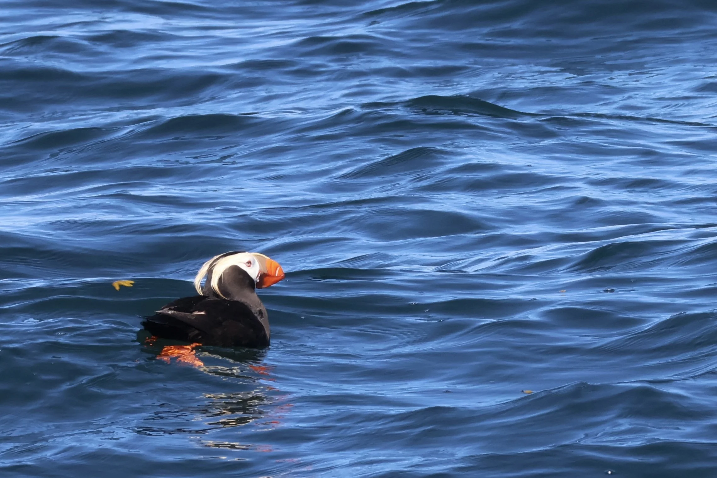
Tufted Puffin- only ~1, 300 puffins left in Washington with a 90% decline in 40 years. State listed only.