
Kelp Forests in Washington
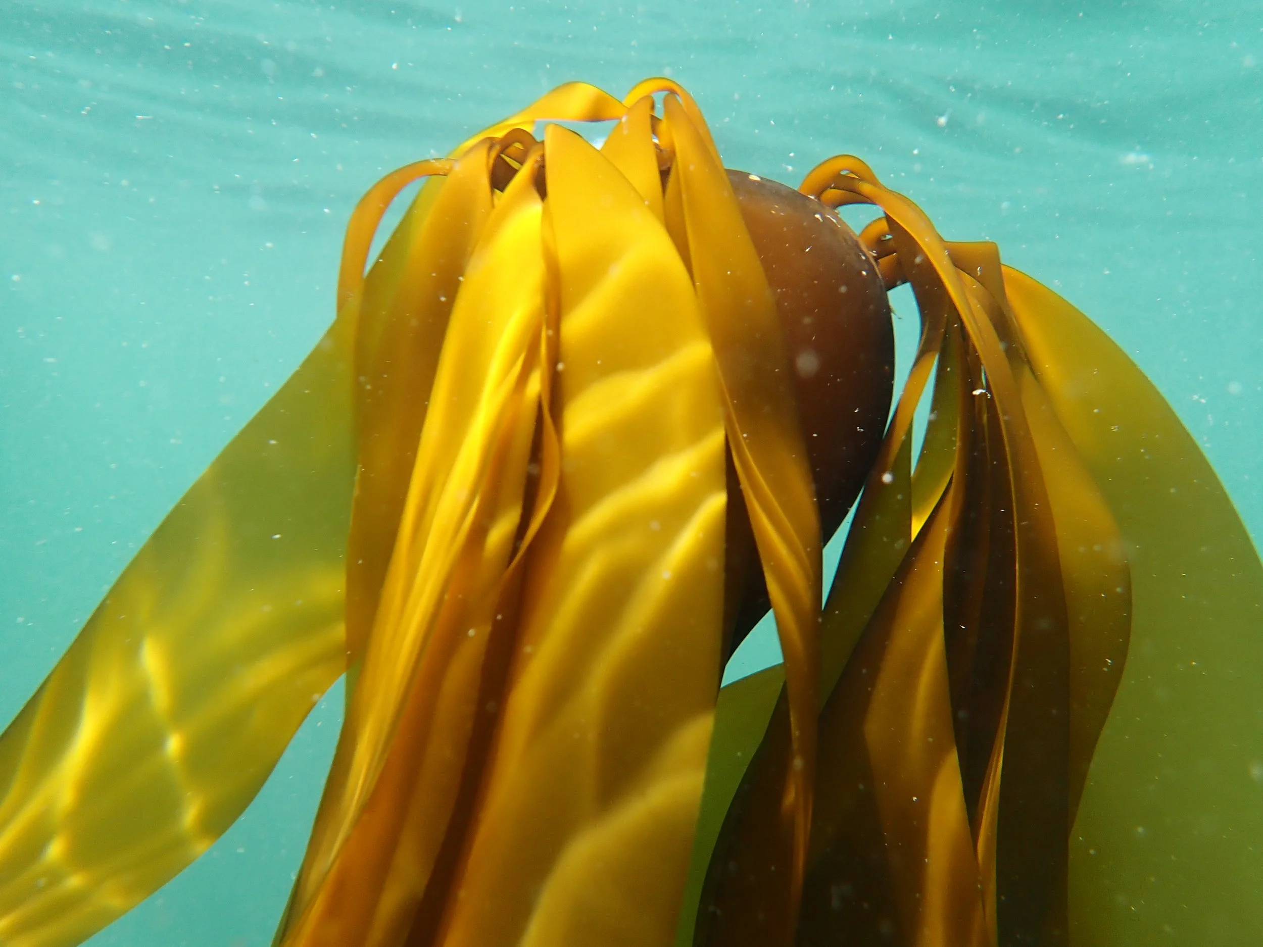
Bull Kelp at Edmonds Underwater Park
A Bull Kelp Surprise at Edmonds Underwater Park
Low tide days usually means one of two things for me: (1) I’m at work doing doing something when I’d rather be (2) out learning in the tidepools. Waders on, head down, numerous squats, starring, contemplating, what I’m seeing But this time I decided to do something different and went for a snorkel instead at Edmonds Underwater Park.
Conditions were fairly clear, good visibility for the sound, and the oh so slightly green-gold light filtering down through the water column. I was swimming along when I realized I’ve arrived at the Bull kelp forest. It got me thinking about what’s actually going on in a place like this. A kelp forest is more than just that long, rubbery stalk topped with a mass of blades, swaying in the current, it is a working ecoystem. And in the Puget Sound, it’s a lot more fragile than I realized.
More Than Just a Plant
Kelp forests are a complex habitat structure an ecological foundation to a great diversity of wildlife. Bull kelp provides critical habitat for juvenile salmon (Chinook and Coho), Pacific herring, surf smelt, Pacific Sand Lance, zooplankton, and more (Shaffer, 2020). Bull kelp is even something of a fashion staple for Southern Resident killer whales, who break off kelp stalks and press them between their bodies to groom one another, a behavior researchers have dubbed "allokelping" (Weiss et al., 2025).
Two species of forest-forming kelp can be found in Washington: Bull kelp (Nereocystis luetkeana) and Giant kelp (Macrocystis pyrifera). Bull kelp is the one you're most likely to run into in Puget Sound, a species with that distinctive single long stipe and bulbous float, rather than the sprawling, multi-stiped canopies giant kelp forms further offshore.
What 145 Years of Data Shows
What makes this particular patch of water worth thinking about isn't just what's there now, it's what used to be there.
he kelp data referenced throughout this post is the result of research stretching back to the 1990s (Berry et al., 2001), and it goes back even further than that: historic imagery has let researchers track long-term changes in kelp forests all the way back to 1878 (Berry et al., 2021).
That comparison is stark. Berry et al. (2021) measured bull kelp extent in 1878 against a modern data (2017) and found a 63% decline across South Puget Sound overall. In some individual sub-basins, the loss was as high as 96%. Losses have persisted across decades and a wide range of conditions.
There is also the pattern of where kelp has persisted. According to Berry et al. (2021), there's also a clear pattern in where kelp has survived. In South Puget Sound, bull kelp mostly held on along shorelines with strong currents, where the water stayed cool and nutrient rich enough for kelp to thrive, and where the current likely kept grazing animals away. Kelp disappeared mostly in warmer, calmer, lower nutrient spots. Interestingly, kelp in more wave exposed parts of the Salish Sea, closer to open ocean, has stayed fairly stable over the same time period. This suggests sheltered kelp beds are more vulnerable to stress, and that the choppier, current swept spots (the ones that make for trickier snorkeling) may actually be acting as safe havens where kelp can hang on.
Data for this map can be found on the Aquatic Resource Division of the Washington State Department of Natural Resources webpage: https://experience.arcgis.com/experience/028ded90c96c46eab38ecf72bd8ec847/?block_id=layout_0_block_9#data_s=id%3AdataSource_1-40%3A5
Watching It in Real Time
That historical baseline is only half the picture. More recent monitoring work has picked up where the century-plus record leaves off: a synthesis of presence-and-absence surveys for floating kelp, gathered using a range of techniques from numerous organizations between 2022 and 2024 (McKenna et al., 2025), gives a new snapshot of the presence of kelp forests.
If you want to see the map yourself, the underlying data lives on the Washington State Department of Natural Resources' Aquatic Resources Division page: Floating Kelp Data Viewer — WA DNR
Additional Layers, If You Want to Dig Further
A few more GIS resources worth layering in if you're exploring this yourself:
NOAA Fisheries (2021): Critical Habitat Maps and GIS Data, West Coast Region: fisheries.noaa.gov
Fisheries and Oceans Canada (2026): Critical Habitat of Aquatic Species at Risk: open.canada.ca
Washington State Department of Ecology (2026): Tribal Lands: geo.wa.gov
Salish Sea Watershed Basin Boundary (2016): geo.wa.gov
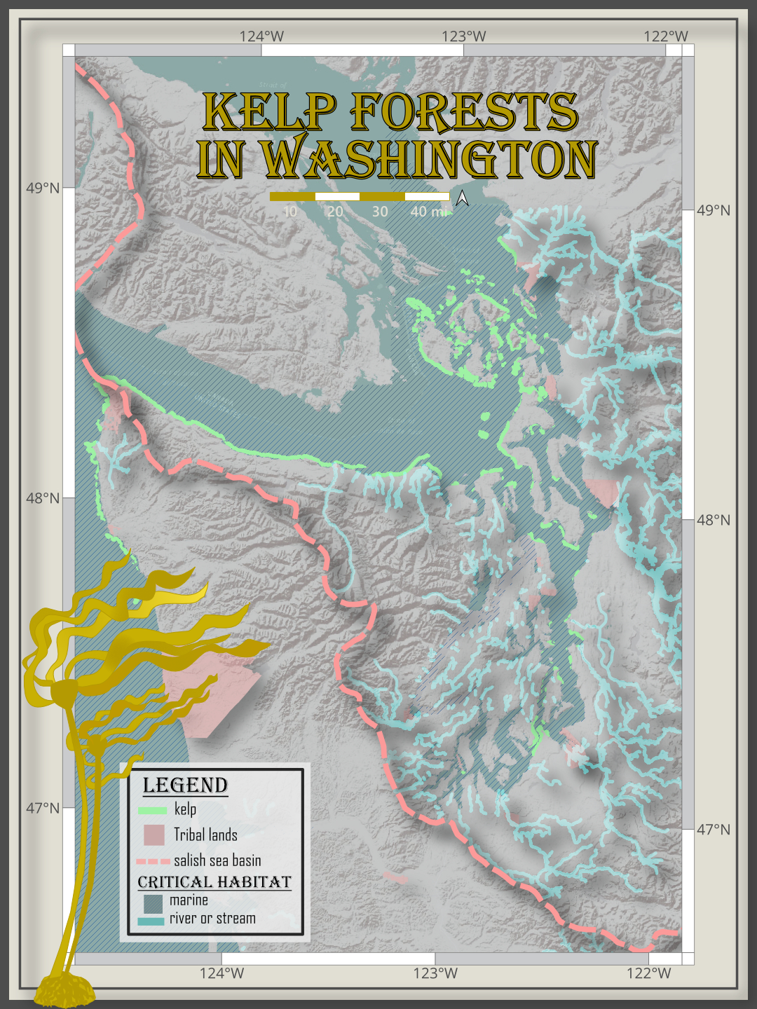
NOAA Fisheries (2021) KCritical Habitat - Maps and GIS Data (West Coast Region)Government of Canada; Fisheries and Oceans Canada (2026). Critical Habitat of Aquatic Species at Risk. Washington State Department of Ecology (2026) Tribial Lands. McKenna, G., Cowdrey, T., Claar, D. (2025) Washington Floating Kelp Linear Extent Data. ERSI Basemap. Map Design and drawing by Seattle Naturalists (2026)